Dressed in a gown of steel grey cloth, trimmed with glacé silk and a “borrowed” tulle veil, Lily Buckland married George Sparrow on 9 April 1916 at Mount Eccles. The wedding was at the home of Lily’s sister and George’s brother, Alice and Charles Sparrow.
Lillian Letitia Buckland was born at Briagolong in 1888, the eldest daughter of William Buckland and Hannah Oakley. The family lived at Toora in Gippsland. George Henry Sparrow was born at Macarthur in 1891, a son of local residents, Abijah Sparrow and Emma Peters. The first instance of a union between the two families was the marriage of Alice Buckland and Charles Sparrow in 1913. How one family from Gippsland and another from the Western District came together is unknown.
George and Lily settled at Lake Gorrie near Macarthur and started their family. Letitia Mavis Sparrow was their first child, born at Hamilton in 1917. Then Charles Robert was born in 1918. In 1920, tragedy struck the family when young Charles, just two years old, fell on a piece of wire in the backyard. The wire went up his nostril and pierced his brain and although taken to Hamilton Hospital, Charles never regained consciousness. In the same year, Lillian saw another sister, Olive, marry a Macarthur lad, returned serviceman William Louden Harman. Seven more children were born to Lily and George over the next ten years, six boys and one girl
A year after the beginning of World War 2, two of George and Lily’s boys enlisted. Allan joined up on 29 June 1940 and served with the 2/23 Australian Infantry Battalion while Roy enlisted on 14 October 1940, serving with the 63rd Australian Infantry Battalion. Allan was discharged on 15 November 1945, however, Roy a Corporal continued on after the end of the war.
On Friday evening 15 March 1946, rain began to fall on the roof of the Sparrow’s home, the likes they had never heard before. At home with George and Lily were three of their children, Mavis, Bruce and Ronald. The rain continued through the night and into Saturday night. On the morning of Sunday 17 March 1946, the Sparrow family woke to the sound of water lapping at their beds. Outside, water was rising rapidly around the property and evacuated. Leaving their domestic animals and poultry to find high ground themselves, Lily and the children climbed into their jinker with George leading the horse, guiding it along the already flooded roads.
It was increasingly difficult for George to distinguish the dangers ahead in the floodwaters, and not far from the house, a wheel of the jinker fell into a concealed hole and upturned, tipping the passengers into the water. George tried desperately to save his family but the water was deep and fast flowing. In his attempt to get help, he became exhausted, collapsed and died.

“SEARCH FOR FLOOD VICTIMS” Advocate (Burnie, Tas. : 1890 – 1954) 23 March 1946: http://nla.gov.au/nla.news-article68968037
A search party was soon looking for Lily and her children. Mavis, Bruce and Ronald’s bodies were found in a hole close to the jinker, the water in the hole was over two metres deep. Lily’s body was found caught in a fence over three kilometres away, such was the force of the water. Mavis was twenty-five, Bruce twenty-two, and Ronald, fifteen. Five family members lost in a terrible tragedy. Rumours were flying that were was no need for them to leave, but servicemen who went to the house during the search supported their actions after seeing the high watermark on the walls. Sadly for the Sparrow family, when one of their surviving sons arrived at the farm the following day, he found the chooks and the household dogs and cats had survived the flood.

The Argus (Melbourne, Vic. : 1848 – 1957) 20 March 1946 http://nla.gov.au/nla.news-page1668019
On the afternoon of Thursday 21 March 1946, the sun broke through the clouds as hundreds made their way to Macarthur’s Church of England for the funeral of the Sparrow family. Among the many floral tributes was a sheaf of flowers sent by the Governor of Victoria and his wife Sir Winston and Lady Dugan, including a personal message for the remaining members of the family. Just days before they had passed through the Macarthur district, including the Sparrow property, to witness the devastation.
The Sparrow family were victims of one of Western Victoria’s worst natural disasters. More used to the ravages of fire, residents were to witness rising rivers and creeks over the weekend of 16 and 17 March that soon turned their part of Victoria into an inland sea.

“FLOODS DEVASTATE WESTERN DISTRICT” The Horsham Times (Vic. : 1882 – 1954) 19 March 1946: 3. Web. 7 Mar 2016 http://nla.gov.au/nla.news-article73076468
The Western District was ravaged by drought from 1939 to 1945 with disastrous bushfires sweeping through the Western District in January 1944.
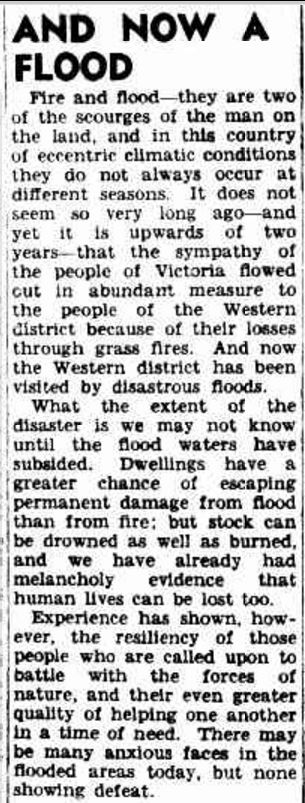
“TUESDAY, MARCH 19, 1946 AND NOW A FLOOD” The Argus (Melbourne, Vic. : 1848 – 1957) 19 March 1946 http://nla.gov.au/nla.news-article2223508
Early in March 1946, parts of Queensland and New South Wales were under floodwaters due to a tropical cyclone. On March 10, cold, wet and windy weather hit Victoria. At 9:00 am on Monday 11 March, the previous forty-eight hours had produced 52 mm of rain in Port Fairy, one of the highest rainfall totals in the Western District for the period while 36 mm fell at Hamilton. A cyclonic depression moved across South Australia in the following days before reaching the Western District on Friday 15 March where it stopped.
The forecast for Victoria published in The Argus of Friday 15 March was for some rain developing from the west and then showers. At 9:00 pm on Friday night, the forecast was “cold and unsettled with some showers. Some heavy rain, with hail, on and south of the ranges”. That heavy rain was of tropical proportions falling from Friday night and through the weekend. By Monday 18 March, The Argus reported the floods covered the Western District from Natimuk in the southern Wimmera to the sea, and to the east to Mortlake. Police headquarters at Russell Street Melbourne said that a stretch of water up to four metres lay from Hamilton to the coast. The map below shows the extent of the rainfall.
There were evacuations from many towns including Hamilton, Portland, Port Fairy, Warrnambool and Casterton. Rescuers took to boats trying to save families, many clinging to the roofs of their houses. Thousands of head of stock were lost, bridges and roads washed away, telephone lines were down and railway lines damaged. There were mass cancellations of trains and buses. Towns were cut off with little means of communication.
On Tuesday 19 March 1946, The Argus published the rainfall totals from 9:00 am on Saturday 17 March until 3:00 pm on Monday 18 March.

“TEMPORARILY FINE TODAY New Depression Approaching” The Argus 19 March 1946 http://nla.gov.au/nla.news-article22235127 .
While many communities were flooded, the following were those most severely affected by the big flood of 1946.
MACARTHUR
Parts of the countryside around Macarthur were under three metres of water stranding families on their roofs hoping for rescue. Around nine kilometres south of Macarthur, on the Port Fairy Road, a bridge washed away. Stock losses in the district were estimated at 5000 sheep and 500 head of cattle. There was concern among authorities about the possible outbreak of disease, with livestock hanging on fences in the floodwaters. Posing a threat to rescuers were hundreds of snakes swimming in the water.
BYADUK/WALLACEDALE/CONDAH/BRANXHOLME
In the Wallacedale/Condah area, ten houses were evacuated and dairy herds were lost. Some parts were under three metres of water. Mr & Mrs Edgar Lacey and Miss Grace Tullett took refuge on the roof of the Lacey home. To shelter from the heavy rain and strong winds, they were able to remove a sheet of tin and climb into the ceiling. With them on the roof, also seeking refuge, were several snakes. A RAAF Catalina Flying boat was flown in to rescue the trio. On arrival, the pilot could not find them so he returned to Williamstown, NSW. Next, a flat-bottomed boat tried but failed to retrieve them. An amphibious car from the Army or Army “duck” was the next plan. Finally, after twenty-five hours, they were rescued but it was several days until the water subsided around their house.

“TOWNSHIP ISOLATED” Examiner, 21 March 1946: http://nla.gov.au/nla.news-article92700639
Miles of fencing and roads washed away and there were heavy losses to livestock including horses and pigs. A beekeeper’s hives bobbed in the water with the stranded bees atop of the boxes. Rescuers saw thousands of snakes while delirious rabbits, marooned on high ground, were caught and their skins sold.
Branxholme had 394 mm of rain from the Friday until the Monday edition of The Argus went to print and the town was cut off by road, rail and telephone. At Byaduk, Mr Tyres rescued seven people from a raft. More were evacuated but were able to return home on Tuesday including Mr and Mrs McCready. Mr J. Scott and Miss Suttie had their homes flooded. David Kinghorn was rescued from a haystack.
HAMILTON
Hamilton saw the heaviest rainfall since records were first kept. Up until 3:00 pm on Monday 18 March 219mm had fallen in fifty-fours, the town’s largest recorded total over the same period. The highest previous monthly rainfall total was 311 mm set in December 1930. The Grange Burn, usually quietly meandering through parts of the town, quickly rose and became a raging river. Around twenty homes near the railway station were evacuated on Saturday 16 March.
Fuel depots near the creek were underwater and hundreds of oil drums from the Shell and the Commonwealth Oil Refinery depots washed down the Grange Burn, accumulating against bridges and fences. Two other fuel depots were badly damaged. One underground petrol tank pushed its way to the surface. Iron from the fuel depots wrapped around trees and plaster from a nearby factory was spread up to almost 100 metres. In those days, the Hamilton swimming pool was on the Grange Burn, at the Braeside Weir, close to the fuel depots.
Sheds beside the swimming pool were swept away and the diving tower was on a lean. At the Ballarat Road and Portland Road bridges, the Grange Burn was between 180 metres to 400 metres wide. The photo below shows the Grange near the Ballarat Road bridge as it is today
A view of the Grange Burn near the Portland Road bridge is below.

‘NO LONGER A CREEK’, The Daily News (Perth, WA : 1882 – 1950), 20 March, p. 1. (CITY FINAL), http://nla.gov.au/nla.news-article78249
Like other roads across the Western District, debris lay across the Portland Road.

STATE OF ROADS AFTER FLOODS (1946, March 22). The Herald (Melbourne, Vic. : 1861 – 1954), p. 5. http://nla.gov.au/nla.news-article245399368
Many bridges and roads around the town were impassable and the drains in Lonsdale Street overflowed. The Hamilton Town Hall became “home” to around seventy evacuees and Mayor Rasmussen called on residents to take those evacuated into their homes. Water went through twenty-five to thirty homes, reaching a depth of almost a metre in some. Mr Brimacombe of Martin Street lost all but one of his 250 chooks.
By Monday 18 March, travellers marooned in Hamilton were taken to Portland. Road connections between Warrnambool and Mt Gambier reopened and by Tuesday morning, Ansetts ran a bus from Horsham to Hamilton. An Army “duck” arrived, using the town as its base.
The photos below, used with permission from Jacinta Hanelt, depict the 1983 floods in Hamilton. They show the same areas flooded in 1946 and although not as deep as those floods, they give an idea as to the extent of the 1946 floods. Despite the damage to the fuel depots in 1946, they remained located close to the Grange Burn.
WARRNAMBOOL
In forty-eight hours at Warrnambool, 228 mm of rain fell accompanied by gale-force winds. There was flooding along the Russell’s Creek, Merri Creek and Hopkins River.
The 3YB radio transmitter was surrounded by three metres of water and sandbags and pumps were called for. At least seven bridges in the shire were damaged. Nearby Dennington was underwater but in South Warrnambool, only four homes required evacuation. Old residents said they hadn’t seen anything like it.
During Monday 18 March, the Hopkins River was rising at a rate of thirty centimetres an hour and later that night, the river burst its banks leaving the highway up to 1.2m underwater. Meanwhile, Allansford residents were preparing to leave their homes.

WARRNAMBOOL 1946. Image courtesy of the State Library of Victoria. http://handle.slv.vic.gov.au/10381/107853
The water at Mr Cox’s house at Spring Gardens, Warrnambool reached over the window sills (below)

M.COX’S HOUSE SPRING GARDENS WARRNAMBOOL ca 1946. Image courtesy of the State Library of Victoria. http://handle.slv.vic.gov.au/10381/10784
The following video from Warrnambool Historical Pictures – Alex Wilkins Collection, gives an amazing insight into how the floods impacted Warrnambool and district and includes some dramatic footage.
The road from Warrnambool to Mortlake was cut after the flooding of the Ellerslie Bridge (below)

The Argus (Melbourne, Vic. : 1848 – 1957) 20 March 1946: <http://nla.gov.au/nla.news-page1668019>.
And the road to Port Fairy was also cut, with the following photo showing the situation about five kilometres west of Warrnambool on the Princes Highway.
The Coppick children were delighted to find their dog Paddy.
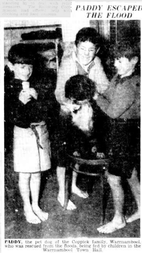
PADDY ESCAPED THE FLOOD (1946, March 18). The Herald (Melbourne, Vic. : 1861 – 1954), p. 3. http://nla.gov.au/nla.news-article245404736
WOODFORD
At Woodford, the local school teacher and his family were stranded in the Woodford Police Station and the post office was underwater (below). A herd of thirty dairy cows drowned.

WOODFORD POST OFFICE “DISASTROUS FLOODS IN VICTORIA.” Townsville Daily Bulletin (Qld. : 1907 – 1954) 21 March 1946: http://nla.gov.au/nla.news-article62889490
KILLARNEY
At Killarney, stranded cows on patches of high ground, helplessly slipped into the floodwaters as exhaustion overcame them. There were huge losses to potato and onion crops and Killarney resembled a lake.

“WESTERN DISTRICTS OF VICTORIA FLOODED.” Daily Advertiser (Wagga Wagga, NSW : 1911 – 1954) 21 March 1946: 1.
The six-week-old baby of Mr and Mrs Patrick Lenehan was floated out a window of their house, the baby’s pram a substitute boat.

“FLOODS LEAVE TRAIL OF DESTRUCTION” The Age, 19 March 1946:http://nla.gov.au/nla.news-article206797296
Stories began to emerge of the heroics in the district. Widow, Mrs Madden and her eight children were saved by Jim Gleeson in his tractor. Another farmer saved an elderly woman from her cottage and Mr J. Ryan was taken to Warrnambool Hospital after being lifted through the window of his flooded home.
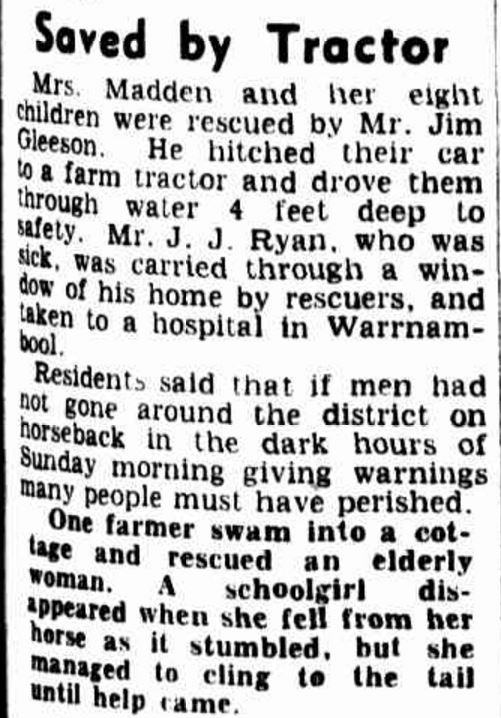
“FLOODS LEAVE TRAIL OF DESTRUCTION” The Age, 19 March 1946: http://nla.gov.au/nla.news-article206797296
Onion crops were wiped out leaving the vegetables bobbing in water or collecting in silt. Farmers tried to salvage what they could.
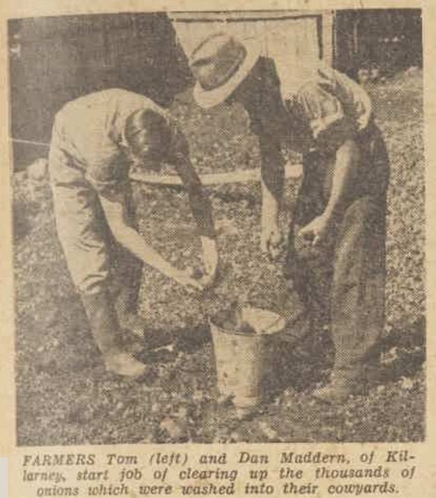
“Green pastures and hard work after floods” The Australian Women’s Weekly (1933 – 1982) 6 April 1946: http://nla.gov.au/nla.news-article47490094
Mrs Madden, rescued with her eight children by Jim Gleeson, returned to her home to begin the cleanup. She is pictured below with her daughter Dorothy cleaning silt from their carpets.

“Green pastures and hard work after floods” The Australian Women’s Weekly (1933 – 1982) 6 April 1946: http://nla.gov.au/nla.news-article47490094
ROSEBROOK
At Rosebrook, the Post Office was surrounded by floodwaters (below)

“FLOODS IN VICTORIA” Newcastle Morning Herald and Miners’ Advocate (NSW : 1876 – 1954) 21 March 1946 http://nla.gov.au/nla.news-article140624307
The bridge over the Moyne River at Rosebrook was also flooded and signals were sent across the bridge as a means of communication (below).

“WESTERN DISTRICTS OF VICTORIA FLOODED.” Daily Advertiser (Wagga Wagga, NSW : 1911 – 1954) 21 March 1946 http://nla.gov.au/nla.news-article145004487
PORT FAIRY
The Moyne River rose rapidly at Port Fairy leading to the evacuation of homes in the eastern part of the town.
Residents in Regent, William and Bank Streets were also evacuated with the water reaching almost a metre in Bank Street and running through houses. To the west of the town, water was up to 1.5 metres deep. Thousands of tonnes of potatoes and onions were lost, and in Port Fairy North, Steel’s bridge gave way. Every hour, reports were arriving of stranded families. Power in the town was interrupted for sixteen hours.
The concrete wharf where fishing boats were moored broke up, threatening to wash boats out to sea. In the end, five boats were lost. Large slabs of concrete from the wharf were swept away and smashed.
Although it’s not clear, the following photo gives some indication of the torrents of water rushing through Port Fairy.

FLOOD WATERS FROM THE MOYNE RIVER, PORT FAIRY. “FLOOD WAVES LASH HOUSES” Sunday Times (Perth, WA : 1902 – 1954) 24 March 1946: 15 (Sport Section).
By Monday 18 March, the threat had subsided slightly but more water was expected to come down the Moyne River and high tide was a concern. As a result, the fire brigade put all men in the town on standby. The main bridge over the Moyne was still standing but had taken a “pounding”. The river reached its peak on Sunday and fisherman stood in waist-deep water desperately trying to secure their boats, and their livelihoods, with some almost drowning.
By Tuesday, houses on the outskirts of Port Fairy East were still half-submerged. Other families were forced to leave their homes, as weakened walls threatened to collapse while the road to Portland was expected to stay closed for some time. In the north-east of the town, built-up floodwaters tore through sand dunes. In doing so, the water escaped to the sea preventing more damage to the town.
The Town Clerk of Port Fairy spoke with John Cain Sr, then Premier of Victoria “Send us some tobacco; there is a famine in smokes here” Bacon, eggs, potatoes and other food supplies were also in short supply. Two Army “ducks” arrived on Tuesday 19 March with butter, eggs, bacon, tinned meat, yeast and tobacco. Another “duck” was soon dispatched. After rescuing stranded families (below) the “ducks” distributed food to isolated families and fodder for stock. They also collected stranded stock, taking them to safety.

“FLOODS IN VICTORIA” Newcastle Morning Herald and Miners’ Advocate (NSW: 1876 – 1954) 21 March 1946: 3. http://nla.gov.au/nla.news-article140624307
There was almost one metre of water in two of Port Fairy’s hotels, including the Caledonian Inn (below). The publican of the inn waded into his backyard to rescue his poultry, then placed them in the inn’s attic. The nearby picture theatre was also flooded.
Jack and Teddy Talbot (below) had a lucky escape as a bridge collapsed just as they were approaching.
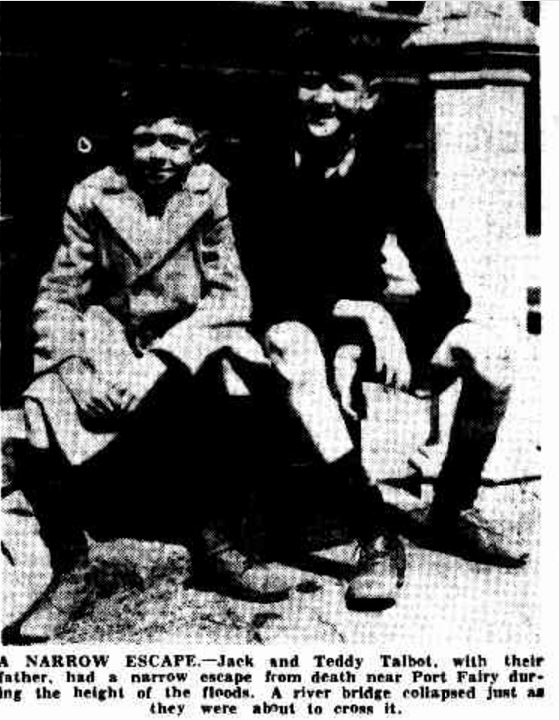
The Age, 20 March 1946: 3. Web. 1 Mar 2016 http://nla.gov.au/nla.news-article206795566

RED CROSS AIDS FLOOD VICTIMS (1946, March 27). Weekly Times, p. 23. http://nla.gov.au/nla.news-article224417630

“Aftermath Of Floods In Western Victoria” The Advertiser (Adelaide, SA : 1931 – 1954) 22 March 1946: http://nla.gov.au/nla.news-article48697059
The photo below shows Mrs Woodrup on a flying fox where Steel’s bridge once stood on the Princes Highway at Port Fairy North.

The Argus, 21 March 1946: http://nla.gov.au/nla.news-page1668077
Cars replaced boats in the streets. Frank and Chris Newman, are pictured below taking Mrs B.Bourke home from the shops.

The Argus, 21 March 1946 http://nla.gov.au/nla.news-page1668077

RELIEF ON WAY TO PT. FAIRY OVER THE RIVER BY FLYING FOX (1946, March 20). The Herald, p. 1. http://nla.gov.au/nla.news-article245392296
Residents in William Street (below) dried clothes and furniture after the water in their street reached a depth of over a metre. By Wednesday 20 March, wet mattresses and pillows hung over fences, furniture was in front yards and clotheslines hung between houses. Dairy farmers unable to get their milk out left cans of milk at each corner and all townspeople were allowed a jug each while the local hotels had a good supply of cream. The damage bill in Port Fairy totalled thousands of pounds.

The Argus (Melbourne, Vic. : 1848 – 1957) 21 March 1946 http://nla.gov.au/nla.news-page1668077
The Port Fairy Cemetery was underwater and even by the end of March, the water was still one metre deep. Eventually, pumps were used to drain it.
Today, there is a reminder of the 1946 flood at the Port Fairy Wharf.
HEYWOOD/PORTLAND
Between Friday night 15 March and Saturday morning 16 March, Portland received 144 mm of rain and low-lying land in the town was flooded. There was a call to divert the water into the sea to save the electricity and gas supplies, but all electricity and gas were cut. The sewage works were deluged and the local fire brigade was busy pumping water. The Portland Showgrounds were under 1.5 metres of water. The town was cut off from Saturday including telegraph and radio communications.
By the morning of Sunday 17 March, the rainfall totalled 203 mm. Fawthrop Swamp was inundated and parts of Bridgewater Road were covered in water. Much of the state’s tomatoes were grown in the district with crop losses eventually leading to a shortage. Local halls and hotels accommodated evacuees. A “howling southerly breeze” with huge waves hit the breakwater (below).

PORTLAND BREAKWATER c1945. Image courtesy of the State Library of Victoria.http://handle.slv.vic.gov.au/10381/97040
At Heywood, until 3:00 pm on 18 March the previous fifty-four hours had produced 335 mm rain leaving many people homeless. Travellers were also stranded as the Portland/Hamilton road was cut including at the Fitzroy River bridge. The local hotel was crowded with evacuees and emergency accommodation was set up in the Heywood Hall.
DARTMOOR
The Glenelg River rose dramatically at Dartmoor as water flowed into the river from tributaries upstream. Five hundred yards of a twenty metre high railway bridge (below) was submerged as was the highway after the river’s level rose fifteen metres. Snakes sought refuge on top of the bridge and iron washed into the pylons, acting as a safe haven for insects, spiders and lizards.
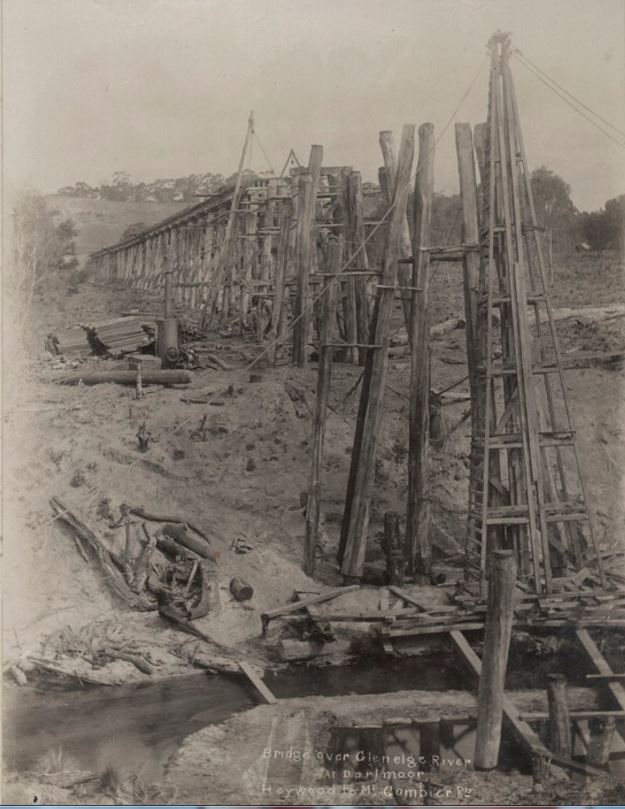
DARTMOOR RAILWAY BRIDGE UNDER CONSTRUCTION c1915. Image courtesy of the State Library of Victoria. http://handle.slv.vic.gov.au/10381/239718
Old residents agreed it was the worst flood in memory. The Glenelg River was over 1.5 kilometres wide and only the tops of telegraph poles were visible. While rowing in the floodwaters, Mr Malseed gathered ten rabbits, twenty-four pumpkins and a number of tomatoes stuck in trees. Seventy drums that had spilt into the river at Casterton were expected to reach Dartmoor.
NELSON
Although Nelson only received 30 mm of rain over the weekend, the Glenelg River was rising rapidly as it neared the sea. A boat shed floated down the Glenelg River with two boats still attached. All sheds on the river bank were submerged as was the kiosk. The monument to Major Mitchell on the Isle of Bags was almost submerged.
Rubbish began to collect at the mouth of the river until the water’s force washed the sandbar out to sea. Meanwhile, residents worked hard to save their bridge (below)

NELSON BRIDGE c1907. Image courtesy of the State Library of Victoria. http://handle.slv.vic.gov.au/10381/211026

“HOW NELSON SAVED ITS BRIDGE” The Age (Melbourne, Vic. : 1854 – 1954) 22 March 1946: 3. http://nla.gov.au/nla.news-article206798952
COLERAINE
Coleraine’s rainfall to Saturday 16 March at 6:00 pm was 122 mm. A flood warning was issued at 2:00 am Sunday morning in the lower part of the town. Bryan Creek rose rapidly flooding shops and houses. Stranded Mrs J. Torney and her baby were rescued from the golf course clubhouse. Over a metre of water sat in the yard of the Post Office (below) by noon Sunday and reached the eaves of some houses.

COLERAINE POST OFFICE. Image courtesy of the State Library of Victoria. http://handle.slv.vic.gov.au/10381/304435
By Monday 18 March, 186 mm of rain had fallen on the town and residents were cleaning silt from their homes. One house, under 1.8m of water in the days before, was left with 50cm of silt. Damage to bridges had blocked the road from Coleraine to Merino and the suspension bridge washed away. There were also large stock losses and miles of fencing demolished.
CASTERTON/SANDFORD
At Casterton, the Glenelg River swelled quickly reaching a height of 6.45m on the river gauge. Seventy drums from the local tip rolled into the river and travelled downstream. By Monday, there were still fears for the safety of three men. Six streets in the town were flooded and Mr Frank Daley and his eighty-three-year-old mother were rescued by police in a boat.

CASTERTON, 18 MARCH 1946. Image courtesy of the State Library of Victoria. http://handle.slv.vic.gov.au/10381/151401
Thirty metres of pipe serving the town’s water supply was washed away while the Major Mitchell monument, south of the town was almost submerged. At nearby Sandford, the McCormack family were stranded. On Monday 18 March, police and an Army “duck” tried to reach them. They were later reported safe.

CASTERTON, 18 MARCH 1946. Image courtesy of the State Library of Victoria.http://handle.slv.vic.gov.au/10381/151401
Mr Anderson took to his canoe.

Western District Floods (1946, March 20). Weekly Times, p. 26. http://nla.gov.au/nla.news-article224430488
AFTERMATH
Just as the water in rivers and creeks was beginning to ease, the following weekend the rain started to fall again. The totals for the period are below, with towns further east of the original floods affected.

“YEAR’S RAINFALL IN THREE MONTHS” The Argus, 27 March 1946:http://nla.gov.au/nla.news-article22237029
On Monday 25 March, Port Fairy was once again isolated and evacuations were considered. Macarthur was expecting floods worse than experienced a week earlier and the Eumerella River burst its banks after reaching a depth of over three metres. Families were evacuated at Bessibelle. The towns of Koroit, Hawkesdale and Branxholme were all at risk of flood. At Allansford. the Hopkins River reached the height of the week before but continued to rise before dropping 1.2 metres on Wednesday 27 March.
At Casterton, the police were warning residents the Glenelg and Wannon Rivers could burst their banks. Homes at Byaduk evacuated a week earlier were again vacated. At Wallacedale and Condah floodwaters still remained from the week before. An Army “duck” was called to Tyrendarra to save a family isolated by the Fitzroy River and Darlot’s Creek. Portland was also cut off via the Princes Highway due to water over the road.
Flooding was reported at Beech Forest and residents living along the Gellibrand River prepared themselves to evacuate. By 29 March, over half a metre of water lay on the Ocean Road at Lower Gellibrand. Meanwhile, at Cobden, 63 mm fell on Saturday 24 March flooding paddocks and stranding cattle. At nearby Cowley’s Creek, stud sheep were rescued from the creek. At Camperdown, a total of 104 mm was recorded over the weekend. Port Campbell, reported the heaviest falls in its history and the township was isolated with over a metre of water over the road. Stranded campers were billeted at the Port Campbell Hotel (below).

PORT CAMPBELL HOTEL. Image courtesy of the State Library of Victoria. http://handle.slv.vic.gov.au/10381/62326
By 27 March, the sun was shining in Warrnambool for the first time in two weeks, but the damage bill and impending recovery left a gloomy forecast for the Western District. Before the floodwaters subsided on 20 March 1946, The Age reported the total damage bill could exceed £2,000,000. On 30 March 1946, the Border Watch reported 150 houses were destroyed and 150 sheds damaged. There were losses to ryegrass seed and potato, tomato, onion and apple crops. One hundred bridges were destroyed. The damage bill for bridges and roads alone, published in The Age of 5 April 1946, was estimated at £76,500. Of that, £25, 300 was in the Warrnambool Shire. By the end of March, the Army “ducks”, vital during the disaster, returned to Melbourne.
On 1 July 1946, twenty-seven men from the flood-affected areas received silver and bronze medals from the Royal Humane Society for their rescue work. They included fishermen and policemen. The men presented with silver medals were:

“AWARDS FOR HEROISM” The Age (Melbourne, Vic. : 1854 – 1954) 2 July 1946: 2. http://nla.gov.au/nla.news-article206375340
The bronze medal recipients were:
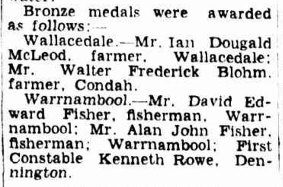
“AWARDS FOR HEROISM” The Age (Melbourne, Vic. : 1854 – 1954) 2 July 1946: 2. http://nla.gov.au/nla.news-article206375340
There was a positive to come from the 1946 floods. Buckley’s Swamp, a peat swamp burning since the fires of January 1944, was finally extinguished.

“FLOOD’S GOOD DEED.” Portland Guardian, 1 April 1946: 2 (EVENING). Web. http://nla.gov.au/nla.news-article64407334
SOURCES
Glenelg Libraries – Historic Treasures – The Floods of Casterton
Trove Digitised Newspapers
The Age
The Argus
Border Watch
Camperdown Chronicle
Horsham Times
Port Fairy Gazette
Portland Guardian
Williamstown Chronicle
State Emergency Service – Casterton Local Flood Guide
State Emergency Service – Port Fairy Local Flood Guide




You must be logged in to post a comment.